Announcement

Collapse
No announcement yet.

Plane Crash in Venezuela

Collapse
X
 
  • Filter
  • Time
  • Show
Clear All
new posts

  • #16
    Hi everybody. This is my first post here, unfortunatelly concerning about this very sad episode.

    This became the worst crash of an ATR-42 ever. The accident is fresh and hypotheses are still being developed. Aparently recue workers are finishing picking up he human rests. But conditions are very rude: Too high (420m or 13780 ft), difficult acces (no road, steep surface) and cold (temperatures near 0 celsius or 32F) with strong winds and quickly varying weather conditions.

    FDRs are in hands of ATR experts. However there are some clues, based in what they found in place. Some rescuers believe that the crash was not frontal but with the belly, since the corpses in the front and rear sections were almost complete.

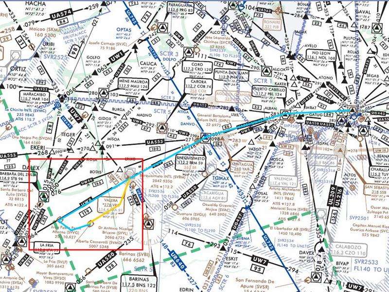
    Wath is true is that the crew were completly off the route, even more around SVMD wich has a narrow acces between the mountains. I'll explain later with figures.

    Regards
    FlyCCS

    Comment


    • #17
      Probable flightpath

      It's early to know the precise path of S3 flight 518 But here you'll find where it crashed.


      Merida valley is very narrow and surrounded by peaks between 13000 and 16000'. When weather conditions are clear enough, airplanes may visually approach and depart from/to CCS through this valley(red-dashed line), leaving the airway in Valera.


      But civil aviation authorities highly recomend to continue to El Vigia and turn to the valley from that point, following Chama River (blue dashed lines). SVMD has no navaids. This longer routes causes a delay of 10 minutes.


      Anyhow, pilots are confident when choosing the formal or risky way to approach or depart. S3 518 crew chose take the visual valley departure with normal weather conditions, but with cloudy mountains. We still don't know why but the airplane made a wide turn and dangerously got over the northern mountains. I don't know whether the crew tried to catch Valera navaids from there (wich implied to overfly the mountains, not possible with only few minutes after taking off) and crashed with the rock wall or that they realised tha they were dangerously flying over the mountains and tried to turn south to the valley without realising that a rock wall was next to them or any other explanation.

      What I have to say is that in decades we never had such a terrible accident in this area. Not even in the 80s 90s when Boeing 727 and DC9 used to go to SVMD, an airport 5007ft high with a 5350ft long runway. Here you'll find picks of SVMD

      Alberto Carnevalli airport, Merida, Venezuela (SVMD)

      Comment


      • #18
        Now that's an interesting flightpath. Given the terrain, I'm not surprised to see the plane head away from Caracas, as I think the pass NE of Merida is about 3,500 metres (from Google maps) and the rest of the mountains are higher still.

        It would be interesting to know what kind of navaids the pilot had locally, either ground based (near Merida, not the Valero ones) or in the aircraft itself.
        Last edited by FireLight; 2008-02-26, 03:30. Reason: note for clarification
        Terry
        Lurking at JP since the BA 777 at Heathrow and AD lost responsiveness to the throttles.
        How often have I said to you that when you have eliminated the impossible, whatever remains, however improbable, must be the truth? Sherlock Holmes

        Comment


        • #19
          Sorry for my late reply

          Originally posted by FireLight
          Now that's an interesting flightpath. Given the terrain, I'm not surprised to see the plane head away from Caracas, as I think the pass NE of Merida is about 3,500 metres (from Google maps) and the rest of the mountains are higher still.

          It would be interesting to know what kind of navaids the pilot had locally, either ground based (near Merida, not the Valero ones) or in the aircraft itself.
          That's correct. The terrain there is high and SVMD is relatively high too: 5007' or 1526m. So, the aircraft takes off Rwy 24 (the airpot dips that direction), climbs for a while and U turns to heading 050. But normally while turning to 050 and overflying SVMD, the aircraft hasn't overpassed the surrounding mountain elevations yet. That's the real danger.

          Here I have some 2006 charts.


          First the general chart with the recommended route UW8: IFR until VIG and visual until SVMD (blue line). In dark yellow, the estimated VFR pilots normally adopt. The red box is the zoomed map beneath


          Here you'll see more in detail the recommended (blue line), also called the Chama valley route, and the usual-by-pilots (dark yellow) route, also called the observatory route (they overfly an ovservatory 3500m high). In green is what the pilots usually perform to catch the observatory route. In red, the probable fatal route of S3 518. All the lines are approximate, since all these are visual.

          I thouth El Vigia had an active NBD, but apparently not. So, every navaid is behind the mountains on each side of Merida. I don't know if that ATR was GPS-equiped or how precise it was. You see that place is dangerous but pilots proceeded correctly all these year and were very confident of flying there safely through the observatory route, until last week.

          Comment


          • #20
            Originally posted by FlyCCS
            Sorry for my late reply


            That's correct. The terrain there is high and SVMD is relatively high too: 5007' or 1526m. So, the aircraft takes off Rwy 24 (the airpot dips that direction), climbs for a while and U turns to heading 050. But normally while turning to 050 and overflying SVMD, the aircraft hasn't overpassed the surrounding mountain elevations yet. That's the real danger.

            Here you'll see more in detail the recommended (blue line), also called the Chama valley route, and the usual-by-pilots (dark yellow) route, also called the observatory route (they overfly an ovservatory 3500m high). In green is what the pilots usually perform to catch the observatory route. In red, the probable fatal route of S3 518. All the lines are approximate, since all these are visual.

            I thouth El Vigia had an active NBD, but apparently not. So, every navaid is behind the mountains on each side of Merida. I don't know if that ATR was GPS-equiped or how precise it was. You see that place is dangerous but pilots proceeded correctly all these year and were very confident of flying there safely through the observatory route, until last week.
            No problem with the timing of the reply.

            Thanks so much for tracking this information down. It serves to deepen the mystery how a trained and experienced pilot would end up so far off course, especially knowing that dangers lurk all around.

            Now to wait and see what the FDR's and initial report can tell us.


            Regards
            Terry
            Lurking at JP since the BA 777 at Heathrow and AD lost responsiveness to the throttles.
            How often have I said to you that when you have eliminated the impossible, whatever remains, however improbable, must be the truth? Sherlock Holmes

            Comment

            Working...
            X